Quaternary deposits
Exploiting and developing quaternary data from the Rhône Valley – Multiple challenges
90% of Switzerland’s land use takes place in the near subsoil, the site of Quaternary deposits. Consisting mainly of loose rock, these soils provide a variety of raw materials (water, mineral raw materials, geothermal energy). Their geological nature also determines certain soil properties that are important for the exploitation of natural resources (hydrogeology, geothermal energy), for the construction of structures, underground or otherwise (geotechnics), or for the prevention of natural hazards (e.g. seismic risk – site effect).
The cantonal cadastre of geological soundings(Géocadastre) now makes it possible to exploit this quaternary data, compiled and interpreted by geologists working in engineering offices. CREALP’s task is to enhance the value of this local data through a global approach based on the wider use of this information. It is therefore involved in a number of regional, cantonal and national projects aimed at exploiting subsurface data to solve a variety of scientific problems.

GEOQUAT: A NATIONAL INFORMATION SYSTEM ON QUATERNARY GEOLOGY | SWITZERLAND
In 2014, the National Geological Survey(SGN) launched the GeoQuat project, which aimed to implement a national information system on Quaternary geology. This information system is intended to enable the visualization, analysis and 3D modeling of subsurface data. The creation of a national database on Quaternary loose rocks is the first stage of the project. It will structure and harmonize the information extracted from geological boreholes, facilitate data collection and entry, and provide a centralized management solution. To implement this database, 4 pilot regions – Visp (VS), Birrfeld – AG, Aaretal (BE), and Vierwaldstätersee (NW, OW, SZ, LU, ZG) – have been selected for the development of targeted products (e.g. 3D geological, hydraulic and hydrogeological models) on specific issues, such as groundwater pollution, seismic risk management or natural resource management.
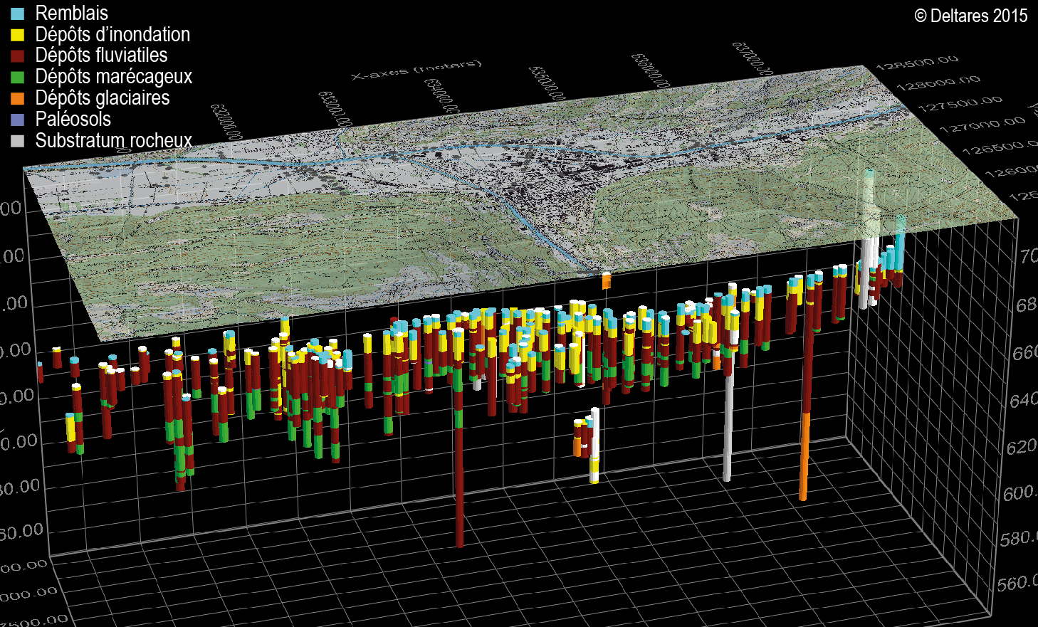
On behalf of the SGN, CREALP provided scientific and technical support for the compilation and digital processing of borehole data for the Visp pilot region. Over 600 boreholes were extracted from the Geocadastre and processed according to the data model developed and supplied by SGN.
The GeoQuat project is conducted in partnership with federal offices(FOEN, SFOE), cantons, federal commissions(SGPK, SGTK), universities(UNIBE, ETHZ), and various private partners(Nagra, Holcim, engineering firms).
GROUNDWASSERPROBLEMATIK Visp | Valais
From the end of 2011 to the end of 2013, the town of Visp experienced an exceptional rise in the water table, reaching almost 2.00 m at low water and 1.50 m at high water. In view of the problems caused, the Canton of Valais, in collaboration with the municipality of Visp, commissioned a study to identify the origin of the rising water table by means of a detailed analysis of the available observation data. As part of this study, the Service de l’environnement(SEN) commissioned Deltares to develop a 3D flow model of the Visp basin, with the aim of gaining a better understanding of the aquifer system and quantifying the relative contribution of the various factors governing its operation and recharge.
CREALP, for its part, was asked to provide the basic geological data required to develop and parameterize the reservoir model (filling and permeability). To this end, some 250 boreholes, extracted directly from the Geocadastre, were subjected to in-depth processing, based on the original geological information recorded in the borehole logs. Each litho-stratigraphic horizon was assigned a lithological code (flood, fluvial, marshy deposits, etc.), a hydrogeological code (confined or unconfined aquifer, aquitard, etc.) and a litho-k code.
The litho-k code method consists in estimating the permeability value of loose quaternary soils on the basis of lithological elements. This method was developed by TNO-NITG and implemented in the REGIS cantonal hydrogeological database(Canton of Valais).