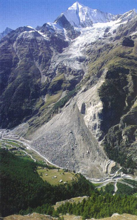
Randa rockfall (1991)
The data collected on this site has been an essential source of knowledge for analyzing the behavior of the Grossgufer massif and managing the associated risks.
Preamble
In the spring of 1991, the village of Randa in the Mattertal valley, some 5 km downstream of Zermatt, was the scene of one of the largest rockfalls in Europe in the 20th century, along with that of Val Pola (Valtelline, Italy, 1987). In all, some 30 million m 3 of material collapsed in three successive phases between April 18 and May 9, 1991.
Damage to road and rail infrastructure and flooding caused by the blockage of the Mattervispa river by the landslide cone amounted to over 80 million Swiss francs.
Geographic and geological context
The village of Randa lies in the Mattertal valley. Morphologically, this valley, which links Visp to Zermatt, is a narrow glacial valley with an asymmetrical cross-section, characterized by the presence of powerful, steep cliffs on the left bank of the Mattervispa. The 1991 rockfall occurred in the immediate vicinity of the village, on the left bank of the MatterVispa at Grossgufer.
The major rockslide at Randa highlighted the scientific shortcomings in predicting such catastrophic events. It was therefore decided to develop a cliff monitoring methodology that would provide a better understanding of the phenomenon of cliff instability and anticipate potential rockfalls. This methodology, named MATTEROCK, was developed as part of the National Research Program PNR31 “Climate change and natural disasters” launched in 1992 by the Swiss NationalScience Foundation (SNSF). A second phase began in 2000. This time as part of a cross-border cooperation program: Interreg II C “Prevention of cliff movements and instabilities”. Funded by the SNSF and the canton of Valais, this new phase of the MATTEROCK project aimed to improve rockfall detection tools, in particular by exploring the possibilities offered by geomechanical analysis.


Information
Project duration: 1991 – 2005

PASCAL ORNSTEIN
Responsable de filière Expert en hydrogéo-informatique
Further information
Jaboyedoff, M., Ornstein, P., & Rouiller, J. D. (2004). Design of a geodetic database and associated tools for monitoring rock-slope movements: the example of the top of Randa rockfall scar. Natural Hazards and Earth System Sciences, 4(2), 187-196.
Baillifard, F. J. (2004). GIS detection of rocky areas with high rockfall susceptibility. University of Lausanne.
Ornstein, P., Jaboyedoff, M., & Rouiller, J. D. (2001). Geodetic monitoring of the Randa site (VS): Management of 1-D and 3-D measurements. Société Suisse de Mécanique des Sols et des Roches, 143, 82-91.
Sartori, M., Baillifard, F., Jaboyedoff, M., & Rouiller, J.-D. (2003). Kinematics of the 1991 Randa rockslides (Valais, Switzerland). Natural Hazards and Earth System Science, 3(5), 423-433.
Pedrazzini, A., Jaboyedoff, M., Derron, M. H., Abellán, A., & Vega Orozco, C. (2010). Reinterpretation of displacements and failure mechanisms of the upper portion of Randa rock slide. In 63rd Canadian Geotechnical Conference & 6th Canadian Permafrost Conference Proceedings, Geo2010 (pp. 913-921).
Consequences of global warming in the Alps
Baillifard, F., Jaboyedoff, M., Rouiller, J. D., & Tosoni, D. (2001). Matterock. In Prévention des mouvements de versants et des instabilités de falaises. Confrontation des méthodes d’étude des éboulements rocheux dans l’arc alpin. Programme Interreg II C – ” Falaises ” Méditerranée Occidentale et Alpes Latines (p. 70-79).
Rouiller, J.-D.: The Randa landslide. Route et Trafic, 92/5, 373-376, 1992.


